
After Dunedin it was good to get out into mountain country again but low cloud made us wonder if our luck had finally evaporated in our quest to see New Zealand's renowned mountain scenery. We had booked four nights in a Twizel Motel about 60km from the National Park entrance, hoping that at least one of those days would be clear enough to see Mount Cook so we anxiously scanned the weather forecasts on our arrival. Weather forecasts in New Zealand seem to be unreliable. You can see why when you look in one direction and there is not a cloud in the sky but in the other it is cloudy and overcast. The forecast seemed to be getting increasingly rainy over the period we were there so we elected to head up to the park the next day.

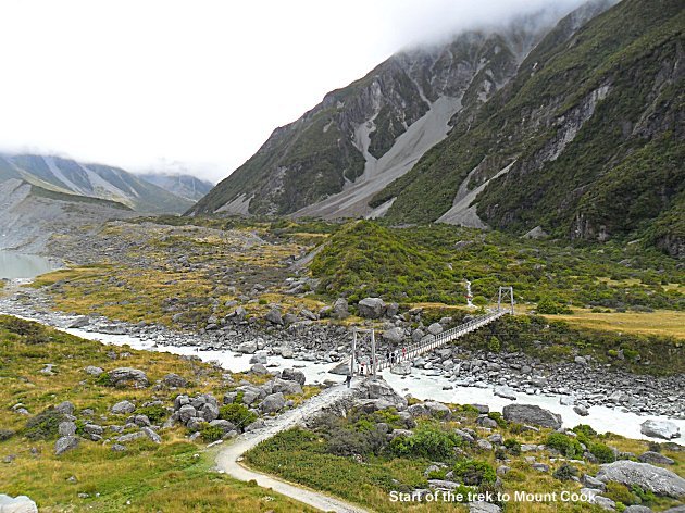
As we drove up along Lake Pukaki the cloud was down to about 1500 metres so if it stayed like that we had no chance of seeing the 3,754 metres of Mount Cook but as we changed for the walk up the Hooker valley a few chinks in the cloud appeared above us on the side of Mount Sefton.
The Mount Cook National Park contains the highest of New Zealand's peaks over 3,000 metres which are permanently covered in snow and ice. Mount Cook was named by the master of a survey ship in 1851 and its Maori name is Aoraki. It was first climbed by three New Zealanders on Christmas Day in 1894.

It did not take too long before the ladies took to the slopes and it was Australian mountaineer Freda du Four who was the first lady. She made the summit in 1910 wearing a skirt and lace blouse. She was also the first woman to climb several other nearby mountains over 3,000 metres at the same time.
All we wanted to do was to look at the mountain and we chose to walk the most popular track up to the terminal lake of the Hooker Glacier, a relatively easy walk of between three and four hours return.

As we crossed the first of two big suspension bridges across the Hooker River the hanging glaciers of Mount Sefton came into view as the clouds lifted and as we turned around the shoulder of Mount Wakefield we caught a glimpse of The icefields of Mount Cook towering above us. The clouds continued to disperse until on our arrival at the Hooker Glacier we had a view of New Zealand's highest mountain in all it's majesty. It towers above all the surrounding peaks and you are left in no doubt that this is the highest by some distance.
Chris and I celebrated with a couple of bottles of Steinlager Pure and we all took loads of photographs with which to bore friends and relatives in the future! Lunch was taken beside the terminal lake afloat with icebergs in hot sunshine before we retreated to the Bar in Mount Cook Village for a refreshing ale.

On the drive back we were struck by the intense colour of Lake Pukaki and walked down to the waters edge to record the scene. The colour of the lake as depicted above is genuine and has not been photoshopped or changed in any way. The colour is pure turquoise.
Back in Twizel (pronounced "Twyzel" and a relic of the hydro development in the 60's and 70's) we sat outside at "Shawtys" bar drinking pints of lovely Emerson Bookbinder, counting our lucky stars for another good day in the mountains. The next day the weather improved even more and we were treated to extensive mountain panorama as we drove up to the park.

This time we turned up the Tasman Valley Road which is a dirt road and the scene of a fatal accident the previous day when a young Christchurch climber skidded off the road. After 8km you come to a car park and another half an hour steep walk to the top of a moraine wall brings you to a wonderful view of the Tasman Glacier. From here you can see a mountain panorama of Mount Cook, Mount Tasman, Mount Haarst, Mount Dixon, the Minarets and the Murchison Glacier rising above the Tasman Glacier, the longest in the southern hemisphere at 27km.

You get some idea of the scale of things when you see a couple of inflatables on the terminal lake, in fact they are so tiny that you can hardly see them. To our left was a great view of the summit ridge of Mount Cook and it's vertical North Face.

After our picnic lunch and ceremonial Steinlager Pure, we descended to the car park and drove up to Mount Cook Village and the DOC Information Centre, quite the best one yet which had static displays detailing the geology, touristic and climbing history of the park and it's mountains.
Finally we walked along the track toward Kea Point for a final look at the mountains towering above us. I am tempted to use the modern Kiwi youth's favourite adjective "awesome" which they use to describe everything from a cold coke to an intense orgasm so I will just call this final view of the mountains, spiritual.
From Twizel we drove through Mackenzie country in fine sunny weather, so named after the original explorer who was a sheep rustler and who happened on this high country plateau in the course of his usual business! As we descended to the coastal plain so the weather deteriorated and it rained most of the way to Kaikoura, our next stop.
Kaikoura is renowned as a place to see Whales, the only problem being you have to pay NZ$145 for a boat trip out to sea or NZ$210 to view them by helicopter. We all decided the whales were too expensive for us. In New Zealand they seem to have commercialised tourism to the n'th degree for example; all of the walks we have done we could have paid hundreds of dollars to have someone guide us to the same place and the NZ Government is considering charging all visitor's to enter it's National Parks. I think most tourists would agree that a small charge at the entrance, as they do in the USA, would not make much difference but the high cost generally of tourist attractions and the distance you have to travel to get here, will deter us from returning more often. Operators would do well to look at reducing their charges in return for attracting more participants to the activities they offer. In general we have not seen many people at the places we have visited and most hotelier's tell us that business is down from last year. Interestingly, they say that some of this downturn is blamed on the Rugby World Cup, particularly in the South Island. Once the pool games had been played in Dunedin everyone disappeared up North!


We had expected a sophisticated tourist centre at Kaikoura but instead it turned out to be in need of a little TLC, not at all an attractive place but it did have a great Butcher, name of Mark Harnett. Yes, the Harnett's are everywhere round here as well as in Palmerston North. We gave him the sausage challenge and he produced his wife's English recipe Pork and Leek gluten free sausages which we all agreed were delicious, as were his porterhouse steaks and his dry cured bacon! The South Island Harnett's can also talk the hind legs off a donkey just like the North Island lot!


Chris spotted a photograph of Sawcut Gorge in the information centre so we resolved to explore it. We drove about 80km north along the coast road then turned inland on a dirt road up the Waima River Valley through extensive vineyards as this was the southern most of the Marlborough regions vines. The road became narrower, climbing up and down the steep valley sides until we came to a sheep station at the end of the road called Isolation and descended steeply into the garden of the Blue Mountain Homestead.


There were several cars parked here plus a couple of Alpacas and we chatted with the owners, who claimed to be related to the Harnett's, and who gave us a map with directions on how to find the gorge. This walk followed the river bed and involved lots of wading through knee deep water for much of the way. The waymarked trail was not that easy to follow and we often found ourselves scrambling over huge limestone boulders so we were all tired by the time we arrived at the gorge which turned out to be quite spectacular with the river having cut down though the rock, reminiscent of phreatic and vadose action in a stream passage underground, extending for perhaps 100 metres.
We ate our lunch and drank some refreshing ale then, by the time we returned to the car about four hours later, we were thankfully too late to buy the hideously expensive crayfish at one of the stalls along the road.
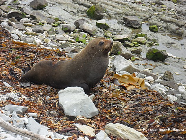
We wandered around the peninsula one day, saw a few fur seals and a whale far out to sea being pursued by a gaggle of boats, probably full of seasick tourists. Chris and Carol met "Big Sid" from Shepton Beauchamp, Somerset, in a local restaurant next door to the Lazy Shag Motel where Big Sid was staying, no really! We were all woken on several occasions in the early hours by the Nationwide credit card lot trying to sort out an emergency credit card after they had sent me one that expired at the end of February so after a few nights of interrupted sleep we set off south again.
Our first stop was for lunch at Waipara Springs Winery. Two of their wines were outstanding. The Pinot Noir was perhaps the highlight, more full bodied than any Pinot we had tasted before. The ladies really liked the Riesling so we bought a couple of bottles of both. We were all disappointed with our lunch of Lamb Rump, very fatty and almost raw but the Pinot made up for it.

Our next destination was the Banks Peninsula and in particular the little town of Akaroa. The peninsula was named after Joseph Banks, the botanist on board Cook's Endeavor. Cook thought it an island as he was well out to sea and could not see the flat ismuth connecting it to the mainland. The other big mistake he made when circumnavigating New Zealand was to think that Stewart Island was a peninsula, not having discovered the Straight between it and the mainland.
The Banks peninsula is the remains of an extinct volcano which became extinct several million years ago. Akaroa sits in the old Caldera which the sea broke into and now forms a lovely fjord like harbour. As you come over the rim of what was the crater you have a glorious view (see above) over the harbour. Akaroa can be seen on the right hand side on the other side of the water.

Fleur Cottage where we were staying was, if a little rustic, a nice old timber 19th century cottage with a garden to match and cherry trees over a courtyard where we could sit outside and eat, just a few yards from the fleshpots of Akaroa. The French were landed here a few days after the Brits, who knew they were coming and had already hoisted the Union flag to claim sovereignty. The French reluctantly became British subjects, settled there and the modern day tourist minded Kiwi's have kept that French connection with French flags flying everywhere, shops like La Boucherie du Village for example, and given French names to most of the main streets. Fleur Cottage is on the Rue Jolie which was tres jolie but about as French as Nempnett Thrubwell! I did notice though that a stone commemorating the French landing had been defaced!

Our first expedition was to the Hinewai Private Reserve. Chris drove us up to the crater edge at the Purple Peak saddle then drove the car down to Otanerito Bay (Long Bay) leaving the rest of us to walk down through the reserve. The saddle is at an altitude of 590 metres and although it is only about 5km as the crow flies, we walked down to sea level and if you straighten out the contours it is a lot further. It took us three hours of mostly steep rough downhill walking through a lot of thick bush and we arrive at the beach knackered!
We visited a couple of other beaches which were all lovely and all situated at the end of narrow fjord like inlets. We did some more walking, wandered around Akaroa looking at the "historic" places and buildings. It was a bit like Russell but the buildings were not so nice, however, the surrounding scenery was truly magnificent.

We left Akaroa and drove over the summit road to Lyttleton where Sues Great Grandparents first landed in New Zealand in 1893. The town had been badly damaged during the earthquakes over the last year and was in quite a sorry state. We tried to continue over to Sumner but the road was closed so we drove back to Christchurch through the tunnel under the mountain. Lyttleton is the seaport for Christchurch and the quays also suffered earthquake damage such that the cruise liners are unable to berth there so anchor in Akaroa Harbour and passengers are bussed the 80km into the city. Akaroa traders have therefore benefited from Lyttletons misfortune.

Our final two nights in New Zealand were spent in a motel close to the airport. We spent our last full day sorting the final details of our car sale with Turners and I had my second haircut of the trip! Then we drove down to New Brighton which is a bit of a dump (apart from a fantastic beach) made even worse by earthquakes. Nearby Sumner is an upmarket dormitory seaside town which had the remains of multi million houses hanging dramatically over the cliff edge which had collapsed and one of these is the home of the owner of the Akaroa cottage we rented.
It is a shame to finish this account of our New Zealand visit on such a sad note but we look forward to going back in a few years to see the progress with rebuilding. We say goodbye here to Chris and Carol as we fly to Melbourne on a 6-20am flight in the morning and they to Sydney on a later flight. They expect to delay their flight back from Sydney to spend some time with their three new granddaughters who are still not out of hospital but are expected out shortly. More about our Australian travels and our return via Singapore will be continued on another page.